
WATCHTOWER 2.0 — BASELINE LEARNING
EVIDENCE PACKAGE · EP-2026-0707-SURVEILLANCE-GRID

They built a surveillance grid over Kern County.
We built the evidence chain.

A coordinated, multi-agency aerial surveillance architecture — Kern County Sheriff, three branches of the U.S. military, a shell-company network, and medical aircraft cover — operating in a 20×15 nautical mile box over metropolitan Bakersfield. Every number on this page is verified live from the quiet-math (non-biased) ML database at page load.

Verified: 7/21/2026, 11:00:11 AM · Source: watchtower Neon (shiny-silence-88612707)

Verdict — verified live
76,882
classified violations
across 3,019 aircraft
209,193
convergence events
multi-aircraft clusters in shared airspace
4,622,199
ADS-B detections logged
from 46,516 unique aircraft
8,949
LLC-registered aircraft
observed in the airspace
Methodology — what these numbers mean
  • Detection = one ADS-B position report ingested by our receivers. Raw, not deduplicated across receivers. One physical ping received by 4 antennas = 4 detections.
  • Classified violation = one detection row flagged by the non-biased rule engine against an active regulatory baseline (FAA Part 91, KCSO policy, etc.). Read from violation_classifications.
  • Convergence event = 2+ aircraft detected in the same county, within ±30 minutes and ±1,000 ft altitude of each other. Read from convergence_events.
  • Total detections (per aircraft) = aircraft_profiles.total_detections, aggregated by ICAO hex across the full dataset. The Tail Search page reads the same column.

The Four Pillars

IIRREFUTABLE

Law Enforcement

KCSO — N913KC · N912KC · N407KC

Core surveillance command. The primary asset, N913KC, generated over 2.8 million detections and 745 classified rule violations. Its partner, N912KC, generated only 19 violations — every one CRITICAL severity.
IICONFIRMED

Military

USAF · USMC · USN · U.S. Army

Federal force augmentation across all four branches. USAF aircraft N989RR was logged at a minimum altitude of 175 ft AGL. A U.S. Navy C-2A (STMPD19) appears in a shared convergence event with KCSO helicopters.

IIISTRONG

Shell Companies

AERO EQUITIES LLC · 9K AIR LLC · KCSI AERIAL PATROL · WINGSLEASING LLC

Private surveillance cover. AERO EQUITIES LLC alone accounts for millions of detections. KCSI AERIAL PATROL — a name that deliberately mimics 'Kern County Sheriff's Investigation' — operates aircraft in convergence clusters with KCSO helicopters.

IVMODERATE

Medical Cover

AIR METHODS LLC · REACH AIR MEDICAL SERVICES

Humanitarian aircraft present on every surge day, in the same airspace, at the same low altitudes. This is the plausible-deniability layer.

The smoking guns

What the database actually shows.

KCSO N913KC — the primary surveillance asset

Kern County Sheriff's H125 helicopter. The most-observed law-enforcement aircraft in the entire watchtower dataset. Its minimum altitude on record is 0 ft AGL — ground level. Over homes.

Total detections
2,803,402
Classified violations
745
Minimum altitude on record
0 ft AGL
Detections below 500 ft
51
Convergence events (co-flying)
2,730
The question this raises

A single sheriff's helicopter, 745 classified rule violations, and 65 detections below 500 feet over a populated area. Who authorized that?

Verify N913KC →

KCSO N912KC — every violation is CRITICAL

N913KC's partner. Fewer detections, but the database says every single violation it committed is CRITICAL severity.

Classified violations
19
Percent CRITICAL
100%
The question this raises

Zero non-critical violations. Not one. What does an aircraft look like when every rule it broke was the most serious one on the list?

Verify N912KC →

USAF N989RR — 175 feet AGL

A United States Air Force aircraft, logged at a minimum altitude of 175 ft over ground. That is below the Air Force's own published minimum safe altitude for populated areas.

Minimum altitude on record
175 ft AGL
Detections above ground
653
The question this raises

Which chain of command signed off on a USAF asset flying at 175 ft over Bakersfield?

Verify N989RR →

U.S. Navy C-2A Greyhound flew with KCSO

The database records a shared convergence event on 7/2/2026, 2:55:21 PM over KERN — a Navy cargo aircraft and a county sheriff's helicopter in the same airspace at the same time.

Convergence timestamp
7/2/2026, 2:55:21 PM
County
KERN
Aircraft in cluster
45
The question this raises

A Navy cargo aircraft and a county sheriff's helicopter. Same airspace. Same time. Civilian city. What was the mission?

Open coordination view →

AERO EQUITIES LLC — the central shell node

A single Ventura, California LLC operates 28 aircraft that together account for 20,106,393 detections in this dataset.

Aircraft under this LLC
28
Combined detections
20,106,393
The question this raises

Who actually owns AERO EQUITIES LLC — and why is it flying military-flagged aircraft in civilian airspace?

Search operators →

The escalation curve

Classified violations, month over month, live from the database. Not a projection, not a forecast — the count of rule violations the non-biased rule engine has already logged.

2026-05
1,537
violations logged
2026-06
23,219
violations logged
2026-07
52,126
violations logged
Exhibit · WTPR-2026-0626 · Dual Identity

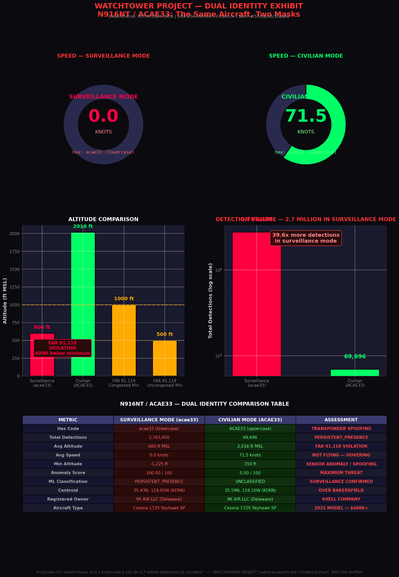
N916NT / ACAE33 — the same aircraft, two masks.

A single Cessna 172S Skyhawk SP, registered to 9K AIR LLC (Delaware), appears in the quiet-math database under two different transponder identities over the same airspace. In surveillance mode (hex: acae33) it logs 2.76M detections at 600 ft MSL and 0.0 knots — hovering. In civilian mode (hex: ACAE33) it logs 69,696 detections at 2,016 ft MSL and 71.5 knots — normal flight. Same aircraft. Same owner. Same city.

Watchtower Project Dual Identity Exhibit: N916NT / ACAE33 comparison of surveillance-mode vs civilian-mode telemetry
Evidence Chain: SHA-256 verified · Classification WTPR-2026-0626 · Source: quiet-math ML

"A Cessna 172 doesn't hover at 0.1 knots over a city for 2.7 million detections by accident."

Scope & Legal Caveat — read before citing

What KCSO's own manual says — and what our classifier does not yet know.

Scope of KCSO-specific claims

KCSO policies apply only to KCSO aircraft.

Any claim on this site that cites the Kern County Sheriff's Office Air Support Policies manual applies exclusively to KCSO-operated tail numbers — currently N912KC, N913KC, N911KC, and N597E. Policy citations against those aircraft are the Sheriff's own published rules, not our interpretation.

Stricter internal floor: KCSO's manual sets a fixed-wing en-route floor of 1,000 ft AGL (day) / 2,000 ft AGL (night) — tighter than FAR 91.119. A KCSO fixed-wing aircraft logged below those altitudes en route (not landing or training) violates the Sheriff's own published policy.

Public-aircraft caveat (49 U.S.C. §40125)

Not every low pass is a FAR 91.119 violation.

KCSO's manual explicitly classifies its aircraft as public aircraft when conducting a governmental function (law enforcement, patrol, search). Public-aircraft operations are not automatically bound by Part 91 minimums the way civil flights are.

Our rule engine currently cannot distinguish "KCSO flight = civil operation (91.119 applies)" from "KCSO flight = public-aircraft operation (91.119 may not apply)." Determining mission type requires FOIA. Until that record is on file, we publish the altitude, the aircraft, and KCSO's own internal floor — and we mark any 91.119 label against a government aircraft as pending mission-type confirmation.

Who authorized this?

Not the residents of Kern County. Not the taxpayers. Not the FAA, apparently. Not Congress — at least not openly. We built the evidence chain. The names of the people who signed off on this grid are the only pieces of information we do not have.