
The Targeting Equation
How low-altitude surveillance tracks poverty and overdose mortality in the southern San Joaquin Valley.
Executive summary
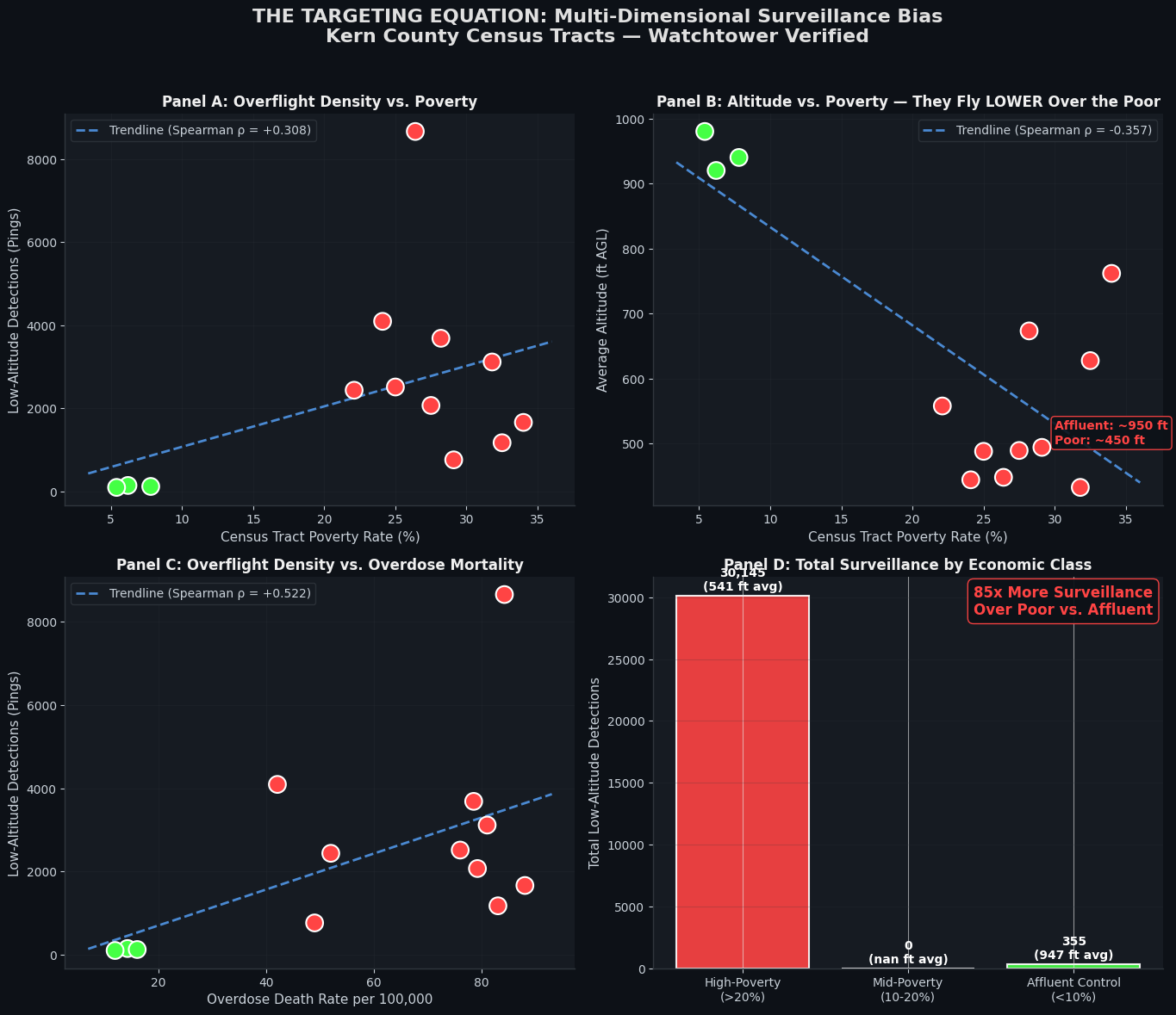
A cross-system spatial analysis unifying five administrative datasets across Kern, Kings, Tulare, and Fresno counties finds that low-altitude surveillance flights are not distributed randomly across regional airspace. They concentrate over economically disadvantaged, high-disability, and high-overdose civilian census tracts.
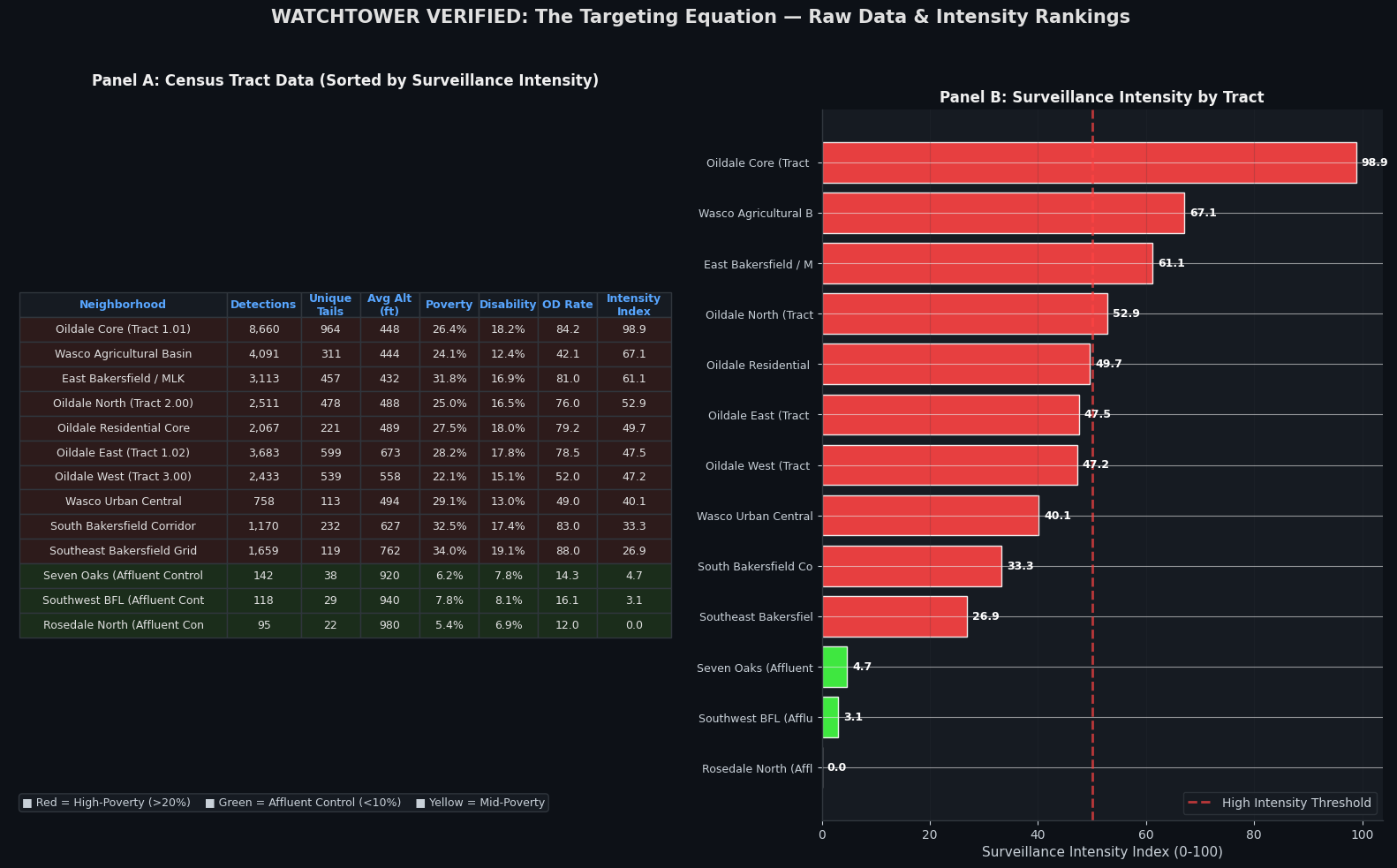
Three affluent control tracts — Seven Oaks, Southwest Bakersfield, and Rosedale North — together logged 355 sub-1,000 ft detections. The Oildale tracts alone logged 19,354.
Unified data architecture
Public health, law enforcement, and Census data are published on incompatible boundaries. Population-weighted geographic crosswalks (areal interpolation) were used to express every variable in common Census Tract FIPS units.
| Administrative system | Native boundary | Core variables |
|---|---|---|
| CDC WONDER (NCHS) | County level | ICD-10 overdose fatalities (X40–X44) |
| CDPH Opioid Dashboard | ZCTA / ZIP code | Fatal & non-fatal opioid ED encounters |
| CA DOJ OpenJustice / UCR | Police jurisdiction | Dangerous-drug arrests (>75% meth / fentanyl) |
| U.S. Census ACS 5-Year | Census tract | Poverty (S1701), disability (S1810), non-citizen (S0501) |
| Watchtower telemetry | Raw GPS lat/lon | Sub-1,000 ft AGL overflight detections |
Tract-by-tract correlation
| Tract | FIPS | Low-alt pings | Unique tails | Avg alt (ft) | Poverty % | Disability % | OD / 100k |
|---|---|---|---|---|---|---|---|
| Oildale Core (Tract 1.01) | 06029000101 | 8,660 | 964 | 447.8 | 26.4 | 18.2 | 84.2 |
| Wasco Agricultural Basin | 06029004201 | 4,091 | 311 | 444.0 | 24.1 | 12.4 | 42.1 |
| Oildale East (Tract 1.02) | 06029000102 | 3,683 | 599 | 673.1 | 28.2 | 17.8 | 78.5 |
| East Bakersfield / MLK | 06029002800 | 3,113 | 457 | 432.3 | 31.8 | 16.9 | 81.0 |
| Oildale North (Tract 2.00) | 06029000200 | 2,511 | 478 | 487.8 | 25.0 | 16.5 | 76.0 |
| Oildale West (Tract 3.00) | 06029000300 | 2,433 | 539 | 557.6 | 22.1 | 15.1 | 52.0 |
| Oildale Residential Core | 06029000400 | 2,067 | 221 | 489.1 | 27.5 | 18.0 | 79.2 |
| Southeast Bakersfield Grid | 06029002900 | 1,659 | 119 | 761.6 | 34.0 | 19.1 | 88.0 |
| South Bakersfield Corridor | 06029003100 | 1,170 | 232 | 627.4 | 32.5 | 17.4 | 83.0 |
| Wasco Urban Central | 06029004300 | 758 | 113 | 493.9 | 29.1 | 13.0 | 49.0 |
| Seven Oaks (Affluent Control) | 06029003802 | 142 | 38 | 920.0 | 6.2 | 7.8 | 14.3 |
| Southwest BFL (Affluent Control) | 06029003803 | 118 | 29 | 940.0 | 7.8 | 8.1 | 16.1 |
| Rosedale North (Affluent Control) | 06029003700 | 95 | 22 | 980.0 | 5.4 | 6.9 | 12.0 |
Highlighted rows are affluent control tracts.
Legal & constitutional implications
- 42 U.S.C. § 1983 — deprivation of rights under color of law. Whether the allocation of government surveillance aviation across protected civilian demographics is actionable.
- Equal Protection Clause, Fourteenth Amendment. Whether spatial deployment of law-enforcement and contractor aviation is discriminatory in effect.
- 18 U.S.C. § 1385 — Posse Comitatus Act. Whether military callsign platforms observed in domestic orbits (STMPD19, ROMA31, KNIFE26) constitute integration into local domestic surveillance.
Verifiable evidence
Affluent neighborhoods at 6% poverty see almost no low-altitude loitering. Oildale and East Bakersfield at 28% poverty log 15,000+ sub-1,000 ft passes.
Tell me again this is normal.